
Stepping into Wales’ distant past
Undiscovered Places >> Europe>>Uncategorized>>Wales>> Stepping into Wales’ distant past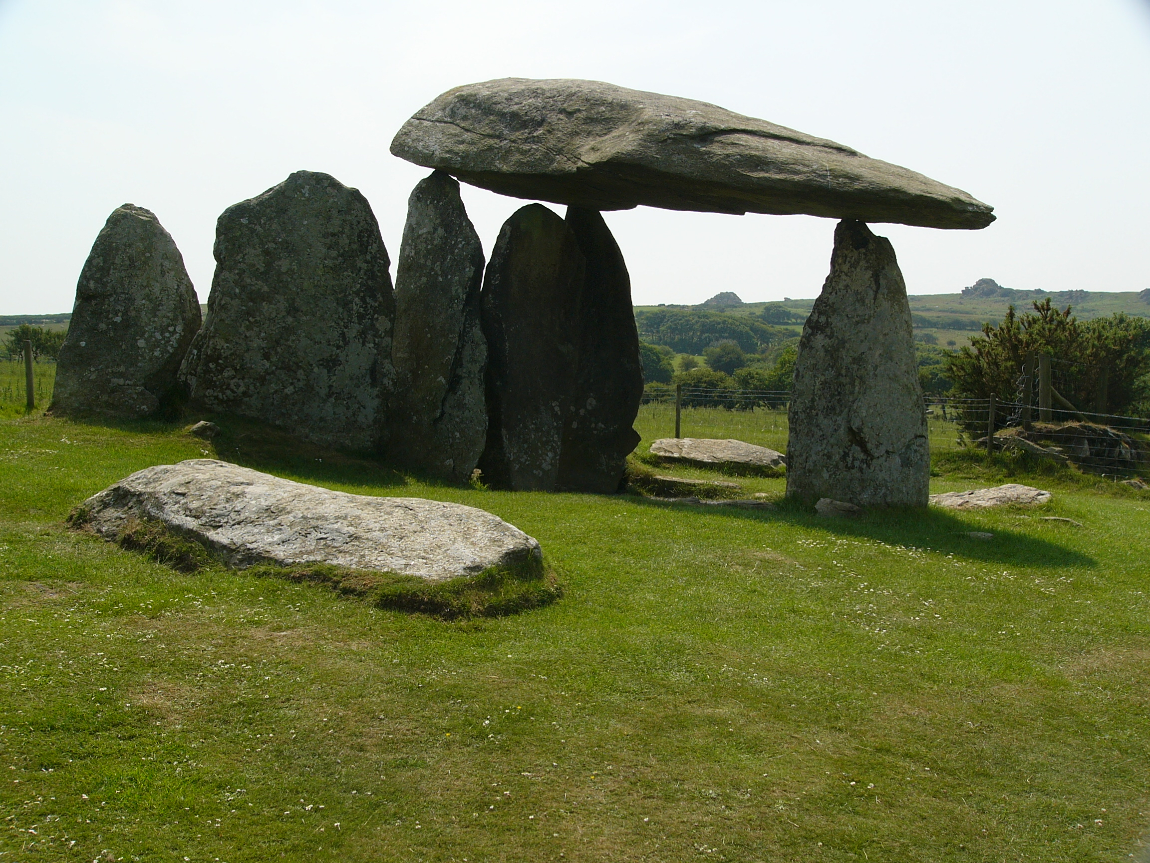
Stepping into Wales’ distant past
Imagine the scene: a hillside in Pembrokeshire, with views down to the coast. It’s 3500 BC and in what we now call the Midde East, Sumerians were building the earliest cities, such as Uruk, Tell Brak, and Hamoukar. Along the River Nile, along the Nile, settlements like Hierakonpolis were growing into major regional centres with thousands of residents. And here in what would become Wales, ancient Britons were building a massive stone structure which we now call Pentre Ifan.

Pentre Ifan is a massive stone structure, consisting of seven giant boulders: The largest is the huge capstone which is 5 metres long, 2.4 metres wide and nearly a metre thick It is probably weighs around 16 tonnes and rests on the tips of three other stones, around 2.5 metres off the ground.[4] As well as those three upright stones, there are three others: two portal stones form an entrance and the third, at an angle, appears to block the doorway.

The dolmen has traditionally been identified as a communal burial site. Under this theory, the existing stones formed the portal and main chamber of the tomb, which would originally have been covered by a large mound of stones or soil about 30 m high. However, more recent studies have produced a different explanation for the monument. For a start, the capstone is far bigger than is needed if the aim is to roof a chamber. Apart from the three pillars holding up the capstone, the others pkay no part. The resulting effect of the enormous stone appearing to float above the other stones would seem to be deliberate and desired. If these are the key elements of the monument then, it is argued, the stones were never designed to be buried within a mound, and they never formed a chamber to contain bones.
So, if what we see today is the monument as it was intended to be seen, that begs the question – why? Possibly, it could be a more elaborate version of standing stones like Stonehenge. It could simply be demonstrating the status and skill of the builders, or adding significance to the place where it stands.
A link to the past
Today, it feels like it IS a significant place. With commanding views over the surrounding countryside, it is certainly a beautiful spot. There is a small car park and then a short walk along a path to the monument itself. It’s one of three Welsh monuments to receive legal protection under the Ancient Monuments Protection Act. On the day we visited, there was a couple there singing the Welsh national anthem quietly, as they stood under the giant capstone. It is an iconic, ancient symbol of Wales’ deep prehistoric roots in the land, representing a cultural heritage that predates Roman and English occupation by millennia.
But there is another side: In Welsh mythology, dolmens are widely believed to be portal sto Annwn, the Welsh Otherworld. Local lore warns that mortals who linger too long at the stones risk losing track of time. Locals have historically reported seeing glowing orbs and ghost-like “death candles” floating around the structure during midsummer nights.
Whatever the legends, the most intriguing question is how on earth did ancient Britons engineer a capstone weighing 16 tonnes to balance on three pointy pillars.

Getting there
Getting to Pentre Ifan requires a bit of planning since it is located in a rural, “off the beaten track” area of the Pembrokeshire Coast National Park. Driving is the most practical option. Pentre Ifan is located just south of the A487 road, roughly halfway between the towns of Fishguard and Cardigan. The nearest coastal town is Newport. There is no dedicated visitor centre or large car park, but there is a free parking lay-by located directly at the gated entrance to the site.
If you want to try your luck with public transport, catch the regional T5 TrawsCymru bus (which connects Haverfordwest, Fishguard, Newport, and Cardigan. Get off at Salutation Inn stop in Felindre Farchog. From there, it’s a 3 kilometre walk uphill along country lanes. If you are walking, don’t rely on live mobile data for Google/Apple Maps – internet access is notoriously spotty once you’re away from the main A487 road and you are likely to find yourself without any guidance mid-walk. Use the Google Maps Offline Download Feature to save the map data locally to your device.
Related Post

The Garden on the Ramparts
Most visitors to Prague's famous and beautiful castle enjoy the historic building and its links…